The most egregious lie underlying the UniParty’s proxy war in Ukraine is the claim that the latter is just another innocent sovereign nation suffering unprovoked invasion and despoilment at the hands of the world latest land-grabbing tyrant.
In fact, however, no nation or state by the name of “Ukraine” ever existed on the maps of the world from the middle ages until the 20th century. Only 100 years ago did modern history’s real tyrants—Lenin, Stalin and Khrushchev – arbitrarily draw its borders on the region north of the Black Sea. But the territories impressed into these borders did not serve the cause of nationhood – only the administrative convenience of their own totalitarian rule and similar map-making caprice across the entire 6,000 mile expanse of the Soviet Union.
Moreover, the current Washington narrative holding that Vladimir Putin’s Russian government in Moscow is laying siege to the freedom loving Ukrainian nation centered in Kiev embodies no small irony. That’s because Russia’s actual origin story starts in Kiev more than 1,000 years ago, when the like named “Vladimir the Great” declared the Kievan Rus for Christianity in 988 AD. The great Russian Orthodox extension of Christendom was thereby extended into central Eurasia and eventually became Czarist Russia.
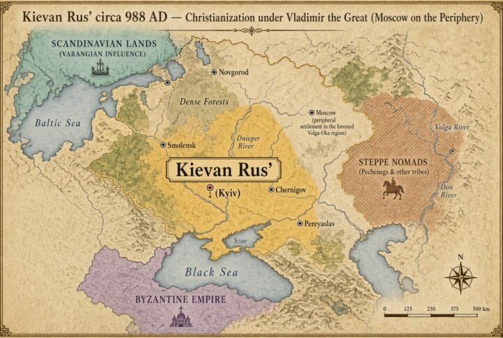
As it happened, Kievan Rus had been the first major East Slavic polity, which took shape in the late 9th and 10th centuries. Viking warrior-traders known as the Rus’ established control over trade routes linking the Baltic to the Black Sea and Byzantium. By the early 10th century, under Prince Oleg and his successors, Kiev on the middle Dnieper River had become the dominant center of the incipient Russian nation.
But the Kievan Rus’ was never a tightly centralized state; rather, it was a loose federation of small principalities whose ruling elite belonged to one of history’s long forgotten dynasties called the Rurikid.
The populations they ruled was predominantly East Slavic, with Finnic, Baltic, and steppe nomadic elements on the periphery. The latter included primitive trading settlements to the northeast in the forested Volga region, which later became the center of Muscovy.
Over subsequent centuries the common language and culture of these East Slavs evolved into the distinct Russian, Ukrainian, and Belarusian branches which populated the yellow areas of the map below. Kiev itself remained the symbolic and ecclesiastical heart of Rus’ through the 11th and early 12th centuries, the period of its greatest prosperity and cultural flowering under Yaroslav the Wise.
Internal fragmentation, however, was already advanced by the mid-12th century. Rival Rurikid princes fought for seniority, and power shifted northward and eastward toward the forested principalities where new centers such as Vladimir and, later, Moscow arose.
The decisive blow came with the Mongol invasion of 1237–1240. Kiev was sacked in 1240, which devastated the southern principalities and left Kiev a shadow of its former self.
By contrast, the northeastern forest principalities (Vladimir-Suzdal and Moscow) proved more resilient: They adapted to Mongol overlordship by collecting tribute, expanded into less contested lands, and gradually accumulated military and fiscal power.
Moscow’s princes secured the title of Grand Prince of Vladimir and the right to gather the Mongol tax, which they used to strengthen their own position. After throwing off direct Golden Horde control in the late 15th century, Moscow’s rulers deliberately claimed the political and religious inheritance of Kievan Rus. This included relocating the metropolitan see from Kiev to Moscow, promoting the idea of Moscow as the “Third Rome,” and presenting themselves as the legitimate continuators of the Rurikid tradition.
This transfer was therefore both a practical consequence of geography and the Mongol catastrophe. And it was also a conscious ideological project that allowed the emerging Russian state to root its legitimacy in the earlier East Slavic polity centered on Kiev.
In any event, by the late 14th and 15th centuries the political center of gravity of the East Slavic world had migrated from the middle Dnieper (Kiev) to the upper Volga basin (Moscow). Kiev remained an important cultural and religious memory, but the emerging Russian state was built in the northeast under Moscow’s leadership.
Alas, history and its geography did not standstill after the retreat of the Mongols had left the region fragmented. Accordingly, the lands around Kiev and stretching toward the Black Sea entered the Polish sphere through a combination of Lithuanian conquest and later dynastic union.
To be specific, during the 14th century the Grand Duchy of Lithuania had expanded rapidly southward, absorbing most of the former Kievan Rus’ principalities, including Kiev itself. At roughly the same time, the Kingdom of Poland had seized the western region of Galicia (including Lviv) following the extinction of its local Rurikid rulers.
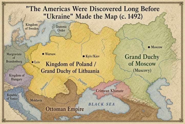
At length, the two states were merged in 1569 under the Union of Lublin, which combined the Kingdom of Poland and the Grand Duchy of Lithuania into what became known as the Polish-Lithuanian Commonwealth. We show this historical entity in the yellow area of the map below.
Under the terms of the union, the vast territories which comprise present day Ukraine and which had previously been held by Lithuania—-Volhynia, Podolia, the Kiev palatinate, and adjacent lands—were detached from the Grand Duchy of Lithuania and attached directly to the Polish Crown. Polish magnates and the Crown administration then extended colonization and military outposts farther south into the steppe (the “wild fields”), albeit the area on the rim of the Black Sea remained under the control of the Crimean Khanate.
The latter was a Turkic-Mongol successor state that emerged in the mid-15th century after the disintegration of the Golden Horde. Centered on the Crimean Peninsula and the adjacent Black Sea steppes, it was ruled by the Giray dynasty, who were descendants of Genghis Khan.
During most of its existence from roughly 1441 to 1783 the Khanate was a vassal of the Ottoman Empire, which provided military and diplomatic support in exchange for the khans’ acknowledgment of Ottoman suzerainty. As it happened, the Khanate’s military power relied on highly mobile Tatar cavalry—while its economy rested heavily on the provision of slaves to the Ottoman markets via raids to the northwest into the neighboring Polish-Lithuanian Commonwealth, to the northeast into the Grand Duchy of Moscow (Muscovy), and to the south into the Caucasus.
In any event, by the time that Columbus discovered the Americas in 1492, would be explorers and map-makers could not have discovered “Ukraine”. That’s because by then—
- the core areas of present-day Ukraine, including Kiev and Lviv, lay within the Polish-Lithuanian state (yellow area of the map).
- Along the eastern regions of today’s Donbas, the Rus’ successor state, the Grand Duchy of Moscow (green area), was pushing westward.
- The southern territories of present day Ukraine adjacent to the Black Sea and Sea of Azov were under the sway of the Mongol/Tartar remnant (pink area), which had become a vassal to the Ottoman Empire east and south of the Black Sea.
Needless to say, therefore, what lay in the present day territory of “Ukraine” was not a modern nation and state aborning, but, instead, the border lands of post-medieval empires. Thereafter these boundaries would be in a continuous flux of expansion and contraction as three regional powers depicted in yellow, green and brown clashed during the centuries which followed.
One essential element of that clash of empires, was the relentless westward expansion of the incipient Russian state, which grew out of the northeastern principality of Muscovy after the Mongol conquests. From the late 15th century the Grand Princes of Moscow expanded in several directions, but the westward movement that eventually reached the Dniester and beyond came chiefly at the expense of the Polish-Lithuanian Commonwealth.
Thus, in 1492 Muscovy stood mostly to the east of present day Ukraine, while the Commonwealth controlled the great majority of the old Kievan lands, including Kiev and Lviv. Over the following centuries, however, a series of Russo-Polish wars, truces, and annexations steadily shifted that frontier westward.
Lands that had been under Lithuanian or Polish rule passed under Russian control. These gains were not matched by equivalent Commonwealth expansion on its western flank sufficient to offset the eastern losses. On the contrary, the Commonwealth was simultaneously pressed by Sweden, the Ottomans, and later by Prussia and Austria on its western boundaries.
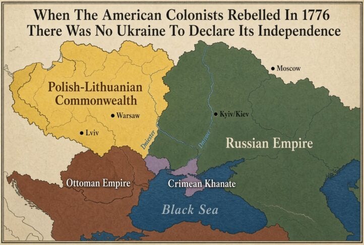
Accordingly, by 1776 the cumulative effect of these earlier wars plus the first Partition of Poland (1772) is visible on the next map below. By then the Russian Empire had advanced westward to the Dniester River in places and held substantial eastern and central Ukrainian territory, while the Commonwealth survived in steadily reduced form.
As it happened, in fact, the first partition of Poland by the tripartite powers—Russia, Austria and Prussia—trimmed the Commonwealth but left it intact; only the second and third partitions (1793 and 1795) extinguished Poland entirely and transferred its remaining Ukrainian territories to the three rising powers of that era.
At the same time, Catherine the Great’s reign in Russia (1762-1796) accelerated both the westward absorption of Commonwealth lands and the southward drive against the Ottomans and the Crimean Khanate.
In that context, Prince Grigory Potemkin famously organized the Russian colonization project in this region. After the Treaty of Küçük Kaynarca (1774) made the Khanate nominally independent of the Ottoman’s, Russian forces occupied Crimea; and in 1783 Catherine annexed the peninsula outright, adding it to the rapidly expanding footprint of the Czarist Empire.
Thereafter, Potemkin founded Sevastopol as the base of the new Black Sea Fleet, giving the Czars their long-sought warm-water port. Simultaneously, he directed the colonization of the steppe lands between the Dnieper, the Don, and the Black Sea—settling it with local peasants, Russian colonists, and foreign immigrants and founding new towns and centers of commerce and industry.
Thus, while the American colonies were separating from Britain, Catherine’s government was colonizing the territories of today’s eastern and southern Ukraine, incorporating them into the Czarist empire under the name “Novorossiya” or New Russia.
A few years latter in his farewell address George Washington admonished his fellow citizens to avoid any and all foreign entanglements. Had he known, he might have called out the tangled cauldron of conflict and colonization then underway on the steppes north of the Black Sea as an example of what was to be avoided.
As we will see in Part 2 and Part 3, the entanglements and intrigues in the region had just begun—even as no sign of a state called “Ukraine” was anywhere on the map. And what was about to unfold there had nothing to do with the homeland security of America—either then or now.
David Stockman was a two-term Congressman from Michigan. He was also the Director of the Office of Management and Budget under President Ronald Reagan. After leaving the White House, Stockman had a 20-year career on Wall Street. He’s the author of three books, The Triumph of Politics: Why the Reagan Revolution Failed, The Great Deformation: The Corruption of Capitalism in America, TRUMPED! A Nation on the Brink of Ruin… And How to Bring It Back, and the recently released Great Money Bubble: Protect Yourself From The Coming Inflation Storm. He also is founder of David Stockman’s Contra Corner and David Stockman’s Bubble Finance Trader.