Part 1
Washington can’t get out of its own way – that’s for sure. After recklessly depleting the nation’s SPR (Strategic Petroleum Reserve) to just 23 days of supply, or the lowest level since the early 1980s, OPEC has now administered a 2 million barrels per day (mb/d) slap in the face.
That is to say, the approximate $1 per gallon drop in gasoline prices since mid-June, which on the margin was facilitated by dumping 1 Mb/d of artificial SPR crude supply into the world market, will presently start marching back uphill. By November 8th Joe Biden will be left high and dry – with angry voters at the polls and a humiliating rebuke by the entire membership of OPEC when it comes to his misbegotten Sanctions War on Russia.
That’s right. OPEC sided with Russia and its own interests, meaning that oil will be heading back to $100 per barrel and gasoline to $5 per gallon for one reason and one reason alone: Namely, owing to the aftershocks of Washington’s sick crusade against the demonized Putin and the vilification of anything and everything Russian.
These sophomoric foreign policy carbuncles, rampant on the banks of the Potomac, have self-evidently and drastically roiled the world’s energy balance. And this disorder is set to get progressively worse when the EU embargo on all seaborne Russian crude oil takes effect on December 5, followed by the virtual certainty of a fiasco resulting from the planned global price cap on Russian oil being aggressively flogged by the Biden Administration.
So the question recurs. What in the world could be so almighty important about the territorial squabble and civil war in east and south Ukraine to justify what amounts to an economic war on the world’s dollar based trade and payments system?
The latter, of course, was the source of the present day prosperity both internationally, and here at home. But in thrall to the diabolical neocon proposition that all property and international commerce is fair game for its hegemonic and statist ends, Washington is now wantonly bringing misery not just to the people and economy of Ukraine, but to the entire global community including the American people.
In this context, let’s cut to the chase. Washington’s proxy war on the ground in Ukraine and Sanctions War on global commerce is not about the high-minded principles – the rule of law and sanctity of borders– ballyhooed by fools like Antony Blinkin. For crying out loud, even if it were, the serial and egregious violator of these principles domiciled on the banks of the Potomac should be the last one to raise the issue.
But, alas, they are not. As we have documented time and again, these grand principles do not apply in any case because there never has been a stable nation-state called Ukraine. Accordingly, what is happening now is not an "invasion" across a legitimate borders, either.
To the contrary, much of the territories which comprise present day Ukraine have been been joined at the hip with mother Russia for most of the last three centuries: During Imperial times that was via old-fashioned vassal protection and sponsorship and during the brutal rule of the Soviet communists between 1922-1991 it was via totalitarian command.
But remove the dastardly work of Lenin, Stalin and Khrushchev during the latter interval, and nothing like today’s map would exist, nor would Washington be starting a global economic war and triggering $5 gasoline prices. That’s because the four territories "annexed" by Russia last week would already have been integral parts of Russia!
For want of doubt here are sequential maps that tell the story and which make mincemeat of the Washington sanctity of borders malarkey. In fact, the approximate territory of the four annexed regions – Donetsk, Luhansk, Kherson and Zaporizhzhia – plus Crimea are evident in the yellow area of this 220-years ago map (@1800).
Collectively, they were known as Novorossiya or "New Russia" and had been acquired by Russian rulers, including Catherine the Great between 1734 and 1791.

As is evident from the year markings in red on the map, the Russian Empire had gradually gained control over the area, signing peace treaties with the Cossack Hetmanate (1734) and with the Ottoman Empire at the conclusion of the the various Russo-Turkish Wars of the 18th century.
Pursuant to this expansion drive–which included massive Russian investment and the in-migration of large Russian populations to the region – Russia established the Novorossiysk Governaorate in 1764. The latter was originally to be named after the Empress Catherine, but she decreed that it should be called "New Russia" instead. Its administrative center was originally at St. Elizabeth fortress (today, Kropyvnytskyi) in order to protect the southern borderlands from the Ottoman Empire, and in 1765 this passed to Kremenchuk
Completing the assemblage of New Russia, Empress Catherine the Great forcefully liquidated the Zaporizhian Sich (present day Zaporizhzhia) in 1775 and annexed its territory to Novorossiya, thus eliminating the independent rule of the Ukrainian Cossacks. Later in 1783 she also acquired Crimea from the Turks, which was also added to Novorossiya.
During this formative period, the infamous shadow ruler under Catherine, Prince Grigori Potempkin, directed the sweeping colonization and Russification of the land. Effectively, the Russian Empress had granted him the powers of an absolute ruler over the area from 1774 onward.
The spirit and importance of New Russia at this time is aptly captured by the historian Willard Sunderland:
The old steppe was Asian and stateless; the current one was state-determined and claimed for European-Russian civilization. The world of comparison was now even more obviously that of the Western empires. Consequently it was all the more clear that the Russian empire merited its own New Russia to go along with everyone else’s New Spain, New France and New England. The adoption of the name of New Russia was in fact the most powerful statement imaginable of Russia’s national coming of age.
Well, yes, but borders!
In fact, the passage of time solidified the border of Novorossiya even more solidly. One century latter the light yellow area of this 1897 map gave an unmistakable message: To wit, in the late Russian Empire there was no doubt as to the paternity of the lands adjacent to the Azov Sea and the Black Sea – they were now part of the 125 years-old "New Russia".

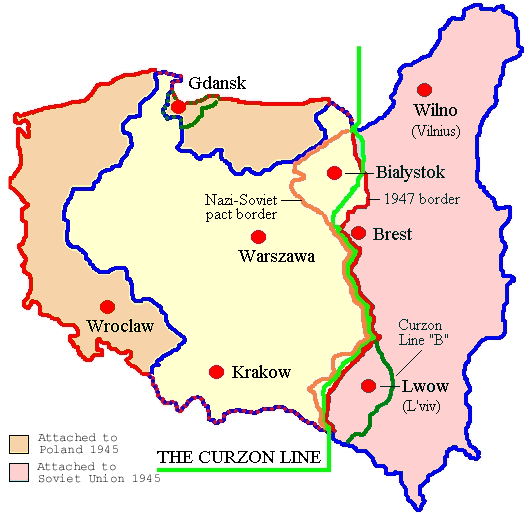
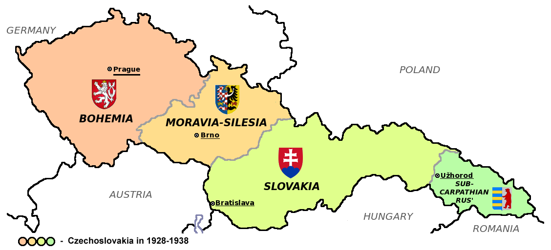
After the madness of WWI and the Bolshevik Revolution, of course, the borders of much of eastern and central Europe were drastically re-arranged. For instance, at the so-called Versailles Peace Conference in 1919, new countries were fashioned from whole cloth ( Czechoslovakia) and long dead countries (Poland) were revived upon both their own ancient lands as well as those of their former neighbors.
Another of these post-WWI creations was Yugoslavia. The kingdom was formed in December 1918, with Serbia’s royal family, the Karadjordjevics, becoming the monarchs of the new country, which was officially called the Kingdom of the Serbs, Croats and Slovenes until 1929 – when it became Yugoslavia. By 1946 it had been incorporated into the Soviet Warsaw Pact, with the borders and constituent parts shown below.
Needless to say, all of these circa 1919 creations and borders have long ceased to exist. After a decade of civil wars and civilian slaughter in the 1990s, Yugoslavia has become seven independent nations – some of which happened only because of NATO military intervention and the majority of which are now actually members of NATO!
By the same token, the present day borders of Poland were moved far to the west at Stalin’s insistence at Yalta. Consequently, the revived nation of "Poland" created by Woodrow Wilson at Versailles to court the growing Midwestern Polish vote, took on a wholly new map.
That is to say, Poland had been dismembered and deleted from the maps by the European powers in the 1790s; had been revived by Wilson’s ignorant demands at Versailles that moved it deep into historic German territories and provided the political fuel for Hitler’s revanchism; and then drastically rearranged again at Yalta where the cynical Churchill and the malevolent Stalin outmaneuvered the senile Roosevelt.
Thus, the area outlined in dark blue was Wilson’s Poland, but the huge swath in pink became part of Russia at Yalta, while the brown areas including the free city of Danzig (Gdansk) and the Danzig Corridor to its right were swiped from the remains of Hitler’s Germany.
The same story holds for Czechoslovakia. Its three constituent nation’s were hammered together at Versailles from the remnants of the Austrian Empire, but eventually went their separate ways after the rule of communism ended in 1991. Today the Czech State and Slovakia exist peacefully side-by-side, and the world is no worse for the wear after their partition.
As it happens, however, there is one politically engineered post-WWI map from the region that hasn’t been undone. For reasons known only by the Washington neocons and Warfare State apparatus, the modern borders of Ukraine – hammered together by the writ of Lenin, Stalin and Khrushchev after 1918 – are apparently the exception to the rule.
Indeed, they are deemed to be so sacrosanct as to justify monkey-hammering the global economy with a destructive Sanctions War, even to the point of risking hot military confrontation between the world’s two major nuclear powers.
Part 2
Like in the case of Poland, the Austro-Hunargian Empire, Yugoslavia and Czechoslovakia, the map of Russia’s border lands changed drastically after the Bolshevik Revolution. The allied powers pilfered its western regions in behalf of Poland at Versailles, while the new communist rulers in Moscow decreed the existence of a state – Ukraine – that had never before existed in the form they gave it.
Thus, in 1919 Lenin created the socialist state of Ukraine on part of the territory of the former Russian Empire. Ukraine officially became the Ukrainian People’s Republic with the capital of Kharkov in 1922 (moved to Kiev in 1934).
Accordingly, the new communist state swallowed up Novorossiya per the eastern and southern portions of the map (pink area). This included the Donetsk, and Lugansk oblasts, as well as the Kherson and Zaporizhzhia regions bordering the Sea of Azov and the Black Sea. These are precisely, of course, the sites of today’s Russia-sponsored succession referendums.
For convenience of administration, if nothing else, the territories of New Russia were added to the original Cossack territories (yellow area) that became a Russian vassal in the mid-17th century, and the central and western regions (light green areas) of Russian suzerainty that were assembled between 1654 and the end of the Czarist Empire in 1917.

As shown more distinctively in the map below, the original Soviet-controlled state of Ukraine (yellow area) continued to expand under Stalin during the WWII era. Thus, in 1939, as a result of the infamous Nazi-Soviet Pact, Stalin annexed the eastern territories of Poland, as designated by the light brown areas of the map. Thus, the historic territory of Galicia and the Polish city of Lvov were incorporated into Ukraine by the joint decree of Stalin and Hitler.
Then in June of 1940, after getting the green light from Hitler, Stalin next annexed Northern Bukovina (green area) from Romania.
Some kind of smarmy paternity, that!

Also, it was one which didn’t last long. When Hitler turned against the Soviet Union in 1941, western and central Ukraine down to Crimea became German territories (yellow area), while even most of the Donbas fell under German military control.
During this era, the local population of western Ukraine was heavily recruited by Hitler’s Wehrmacht. It was then that Ukraine’s Nazi legacy was created, as the pro-German populations joined the attack on all things Russian.
The mayhem in the Russian speaking areas of Novorossiya and related areas conducted by the German recruits were never forgotten by the blooded populations of these regions. Nor were the pro-Nazi wartime heroes like Stepan Bandera forgotten in the anti-Russian areas.

Still, Stalin was not yet done gifting the world today’s state of Ukraine. At the Yalta conference in 1945, upon Stalin’s insistence to Churchill and Roosevelt, the Hungarian Carpathian Ruthenia (blue area) was incorporated into the Soviet Union and added to Ukraine.
Taken together, these Stalinist seizures are now known as Western Ukraine, the people’s of which understandably do not cotton to things Russian. At the same time, the 85% Russian-speaking population inhabiting the gray area (Crimea) was gifted to Ukraine by Khrushchev in 1954 for the very reason of extending his own accession to the communist dictatorship.
Nevertheless, after the disintegration of the Soviet Union, Ukraine inherited these communist-confected borders within which there were upwards of 40 millions Russians, Ukrainians, Poles, Hungarians, Romanians, Tartars and countless lesser nationalities – all trapped in a newly declared country in which they didn’t especially wish to reside.

Needless to say, the so-called "stable" borders of Ukraine between 1954 and the collapse of the Soviet Union in 1991 prove exactly nothing about the "rule of law". The fact is, the Soviet-puppet rulers of Ukraine during that four decade period controlled the unhappy populations that had been slammed together by their communist overlords by the iron fist of totalitarian rule and violence.
Indeed, no sooner had the Soviet Union been dispatched to the dustbin of history than a nascent movement to revive the independent state of Novorossiya quickly developed in the Donbas and southern regions of communist Ukraine. This movement had begun in Odessa for the restoration of Novorossiya region, and while it soon failed, the initial focus had centered on the Odessan, Mykolaiv, Kherson, and Crimean oblasts, with eventually other oblasts joining as well.
In any event, the newly christened independent state of Ukraine essentially struggled for breakup and partition under the guise of democratic elections during the next 25 years. This culminated in the 2010 election, which was drastically lopsided among the regions, and which eventually gave rise to the Washington sponsored Maidan coup of February 2014.
The latter, of course, drove the pro-Russian winner of the 2010 election from office; ushered into power in Kiev the legacy crypto-Nazi forces from western Ukraine, which presently unleashed an anti-Russian campaign culminating in the burning alive of dozens of Russian speakers in an Odessa union hall; and eventually fostered Kiev’s brutal war against the separatists of the Donbas, who soon realized that they had no future under the new nationalist government.
Nevertheless, the map below is truly the picture worth a thousand words. The dark red areas in the former Galicia, which Stalin had annexed in 1939, and which had become a hotbed of support for the Nazi SS during WWII, voted for the nationalist candidate Tymoshenko by overwhelming 90% plus margins.
At the same time, in the Donbas and the south, the dark blue areas show the presidential vote was overwhelmingly for the pro-Russian candidate, Janukovych, by 80-90% of better.
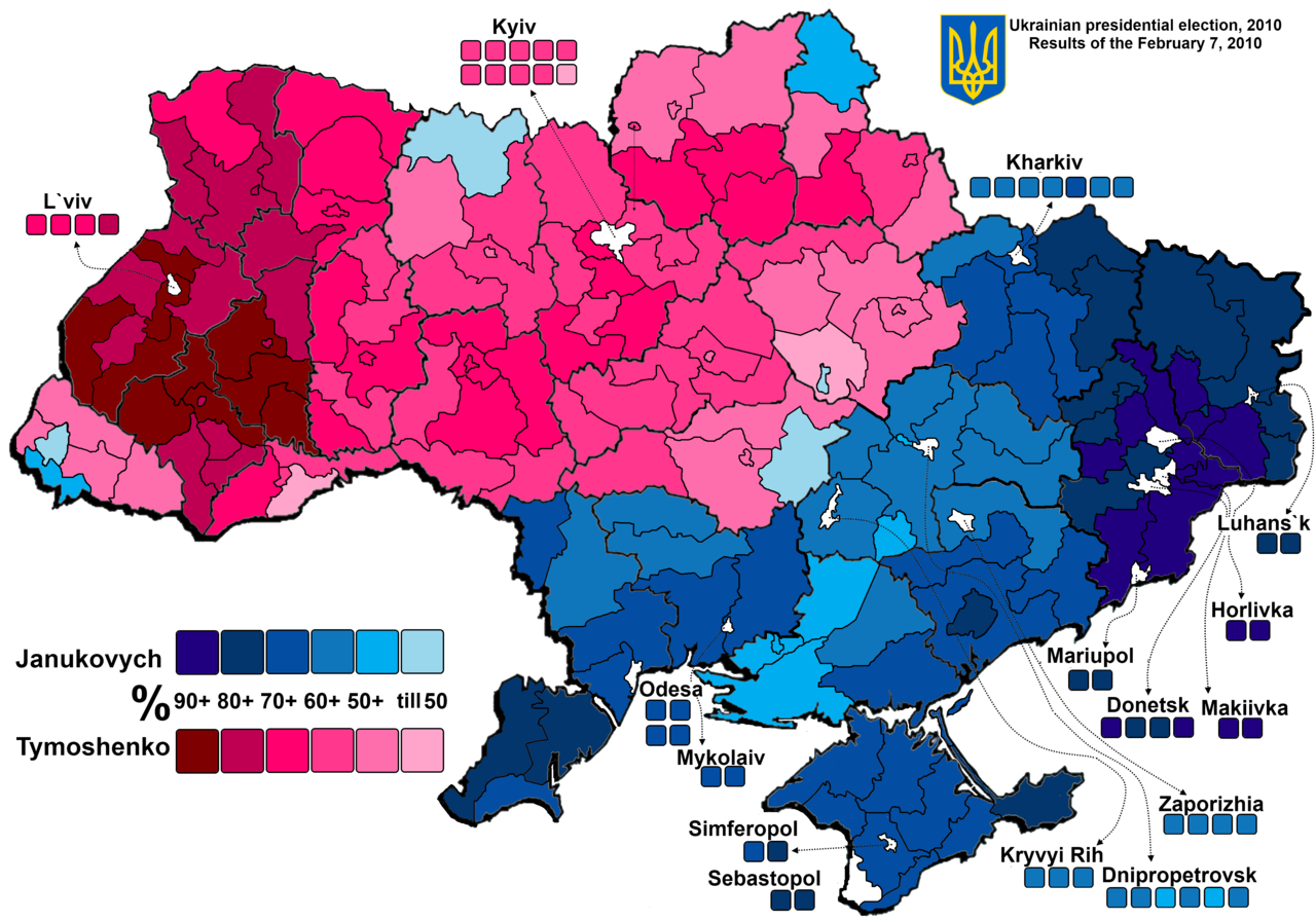
So the question recurs. The discordant populations of the artificial state of Ukraine have shown at the ballot box during elections that were mainly free and fair according to international observers, that they wanted a divorce and partition. Long before the kinetic war incepted on February 24th, Vlad Putin actually stated the situation as clearly has can be done.
That’s new Russia (Novorossiya), to use the terminology of the Tsarist Russia: Kharkov, Lugansk, Donetsk, Kherson, Nikoleav, and Odessa were not part of Ukraine back then. These territories were given to Ukraine in the 1920s by the Soviet government. Why? God knows!
The above statement was made in 2021. At that time there was ample opportunity for Washington and NATO to negotiate the partition that was warranted by every consideration of history and the bloody evolution of the modern Ukrainian borders by the communist rulers of the era.

But that did not happen. The insanity of today’s proxy war and global sanctions mayhem happened solely due to events not on the ground in Ukraine, but on the banks of the Potomac where the sunshine warriors of the neocon persuasion can’t get enough of war and hegemony.
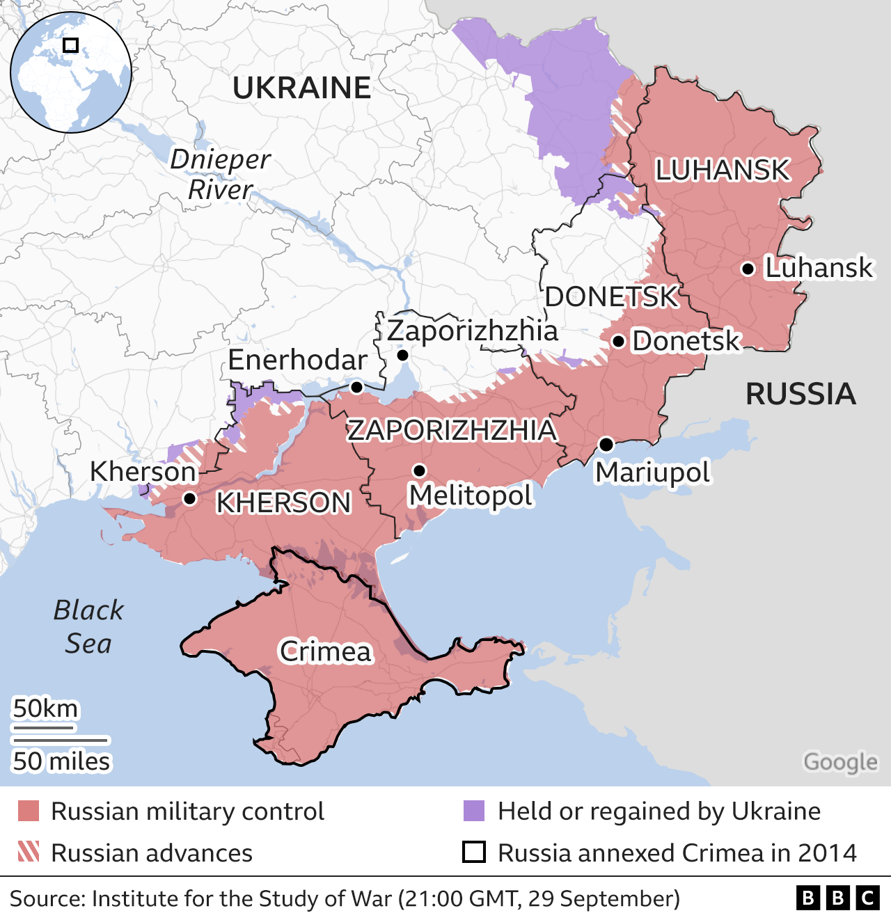
Alas, here is how the map looks after the four referendums and the 2014 return of Crimea to Russia. That is, it is exactly as Putin proposed and as the history of these maps overwhelmingly warrants.
Yet the virtual criminals running Biden’s foreign policy and calling the shots at NATO think these borders are worth other people dying for and the world suffering economically for.
No, it is the sick puppies parading along the banks of the Potomac that deserve to the suffer the condign punishments that their unspeakable follies warrant.
David Stockman was a two-term Congressman from Michigan. He was also the Director of the Office of Management and Budget under President Ronald Reagan. After leaving the White House, Stockman had a 20-year career on Wall Street. He’s the author of three books, The Triumph of Politics: Why the Reagan Revolution Failed, The Great Deformation: The Corruption of Capitalism in America and TRUMPED! A Nation on the Brink of Ruin… And How to Bring It Back. He also is founder of David Stockman’s Contra Corner and David Stockman’s Bubble Finance Trader.